Courses

Geothermal Systems around the Globe

Although the top geothermal power plant in the world based on net capacity is located in the United States (The Geysers Geothermal Complex in California), there are other geothermal projects around the world contributing in an important way to global net capacity. The table below highlights countries contributing significantly to the global portion of power production from geothermal resources.

Global Geothermal Power Production

Country Installed Capacity in MWe Global Portion of Installed Capacity
U.S. 3,794 23.5%
Indonesia 2,356 14.6%
Philippines 1,935 12.0%
Turkey 1,682 10.4%
New Zealand 1,037 6.4%
Mexico 963 6.0%
Kenya 944 5.9%
Italy 944 5.9%
Iceland 754 4.7%
Japan 621 3.9%
Other 1,096 6.8%
Total 16,127 100%
Table Data Source: ThinkGeoEnergy Research1ThinkGeoEnergy. 2023, June 29. https://www.thinkgeoenergy.com/thinkgeoenergys-top-10-geothermal-countries-2022-power-generation-capacity-mw

Now that we have seen some of the numbers per country, let’s take a look at a few important projects in some of these countries.
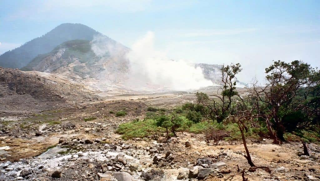
Indonesia

The Darajat Geothermal Power Station, has a nameplate capacity of 270 MW of electricity. It is located in Garut, Pasirwangi District, Indonesia. The three units (power plants) in the station generate electricity that serves the Bali and Java provinces. The three plants were commissioned in 1994, 2000 and 2007. The Darajat geothermal power station uses dry steam technology.

A view of volcanic topography in western Java, Indonesia

The integrated energy company Chevron (as Chevron Geothermal Indonesia Ltd.) began operating Darajat’s third unit in 2007 as the company’s first project to earn carbon credits for reducing emissions. The Darajat III unit has been approved by the United Nations as a Clean Development Mechanism project, a market-based instrument of the United Nation’s Kyoto Protocol to encourage implementation of cost-effective greenhouse gas reductions.2Think GeoEnergy Map. (n.d.) Darajat. (accessed 2023, July 5). https://www.thinkgeoenergy.com/map/3Main World Geothermal Project. (accessed 2023, July 5). https://www.oil-gasportal.com/main-world-geothermal-projects/4Chevron Expands Geothermal Operations in Indonesia. (2007, August 13). Chevron press release. https://chevroncorp.gcs-web.com/news-releases/news-release-details/chevron-expands-geothermal-operations-indonesia

Location of the Darajat Geothermal Power Station in Indonesia (above). The station is in the Mt Kendang area of the island of Java (below) where volcanic mountains (2,000 m above sea level) are evidence of the importance of plate tectonic activity to the availability of geothermal resources in this region. The relief map of Java (below) clearly shows the many volcanoes in the region, characteristic of the “Ring of Fire” region.5Darajat Power Station. (2021, February 19). Wikipedia. https://en.wikipedia.org/wiki/Darajat_Power_Station
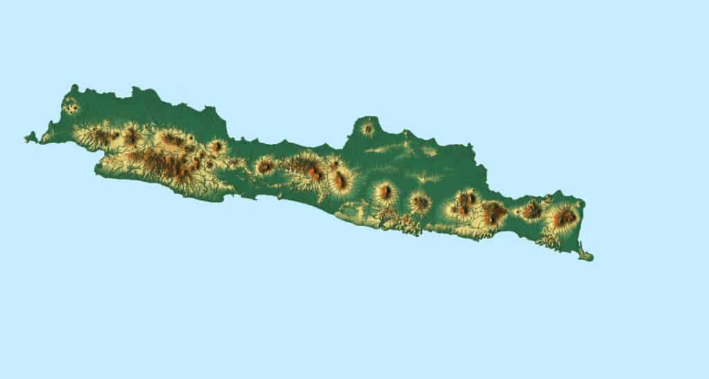
Relief map of Java showing volcano topography

Philippines

Makban Geothermal Power Complex, also known as Makiling-Banahaw Power Plants, is located in Laguna and Batangas, Philippines, with a nameplate capacity of 458MW. The facility and the geothermal field are named after Makiling and Banahaw mountains (see photo below). These mountains originated as volcanoes and are characteristic of the “Ring of Fire” region. The Chevron Geothermal Philippine Holdings, Inc. under a service contract with the state-owned National Power Corporation (NPC) developed a geothermal station at the field which was commissioned in 1979. AP Renewables took over the plant in 2009. The complex uses binary and flash technologies for power generation.6Think GeoEnergy Map. (n.d.) Makban. (accessed 2023, July 5). https://www.thinkgeoenergy.com/map/7Main World Geothermal Project. (accessed 2023, July 5). https://www.oil-gasportal.com/main-world-geothermal-projects/8Mak–Ban Geothermal Power Plant. (2023, April 23). Wikipedia. https://en.wikipedia.org/wiki/Mak%E2%80%93Ban_Geothermal_Power_Plant

Mount Makiling, a dormant stratovolcano, located in the provinces of Laguna and Batangas on the island of Luzon in the Philippines1Mak–Ban Geothermal Power Plant. (2023, April 23). Wikipedia. https://en.wikipedia.org/wiki/Mak%E2%80%93Ban_Geothermal_Power_Plant

Mexico

The Cerro Prieto Geothermal Field is located in the northern part of Baja California, Mexico, 30 km south of the border with the United States. It is owned and operated by the Comisión Federal de Electricidad (CFE). The power station features five plants, comprised of numerous units, with a nameplate capacity of 820 MW. The first plant was commissioned in 1973, while the fifth plant was commissioned in 2009. The complex is owned by the Comision Federal de Electricidad, a state-owned company in charge of generating, transmitting and distributing electrical energy in Mexico. Cerro Prieto is a large high-temperature (280-350ºC), liquid-dominated field, contained in sedimentary rocks.9 Puente, H.G., and Rodriguez, M.H., 2000, 28 years of production at Cerro Prieto Geothermal Field, Proceedings World Geothermal Congress 2000. Flash technologies are used in power generation.10Think GeoEnergy Map. (n.d.) Cerro Prieto. (accessed 2023, July 5). https://www.thinkgeoenergy.com/map/

Italy

The Larderello Geothermal Complex is found in central Italy, near Tuscany. Larderello is comprised of 34 plants with a nameplate capacity of 770 MW of power generation. The complex is also one of the oldest in the world, with the first plant there being commissioned more than a century ago, in 1913.11Main World Geothermal Project. (accessed 2023, July 5). https://www.oil-gasportal.com/main-world-geothermal-projects/ The history of Larderello and geothermal power generation is further discussed in a subsequent lesson in this course. The geothermal field at Larderello is one of the few systems producing superheated steam, and thus use dry steam technologies. The anomalously high heat flow in the Larderello area is related to magma that was emplaced in the region deep in the subsurface ~5-3 million years ago. Faults in the area allow for fluid transport and manifestation of steam at the surface.12Minissale, A. 1991. The Larderello geothermal field: a review. Earth-Science Reviews. doi: 10.1016/0012-8252(91)90018-B. Reservoir depths at the geothermal field range from 700m to 4,000m below the surface.13Main World Geothermal Project. (accessed 2023, July 5). https://www.oil-gasportal.com/main-world-geothermal-projects/

True or False: Italy's geothermal resource at Larderello is related to the "Ring of Fire" plate tectonic activity.
True

Incorrect

The geothermal activity at Larderello is a result of the emplacement of hot magma in the region associated with geologic activity ~5-3 million years ago and not related to the "Ring of Fire" located around the rim of the Pacific Ocean.

False

Correct

The geothermal activity at Larderello is a result of the emplacement of hot magma in the region associated with geologic activity ~5-3 million years ago and not related to the "Ring of Fire" located around the rim of the Pacific Ocean.

Iceland

The Hellisheidi Geothermal Power Plant is a flash steam, combined heat and power plant (CHP) located at Mount Hengill, approximately 20km east of the capital city of Reykjavik. It serves electricity to the Icelandic city of Reykjavik, and is the largest power generating plant of any kind in Iceland. The power plant was commissioned in five phases from 2006-2011. It covers an area of approximately 13,000m². The plant has a production capacity of 300MW of electric energy and 400MW of thermal energy.14Main World Geothermal Project. (accessed 2023, July 5). https://www.oil-gasportal.com/main-world-geothermal-projects/ The power plant uses flash technologies for generating electricity.15Think GeoEnergy Map. (n.d.) Hellisheidi. (accessed 2023, July 5). https://www.thinkgeoenergy.com/map/

Natural conditions in Iceland are favorable for geothermal power production. The island country has some of the most geologically active territory on Earth. Iceland straddles the Mid-Atlantic Ridge (a rift between continental plates), and lies over a volcanic hotspot, resulting in pronounced volcanism and geothermal activity. In addition, Iceland’s underground water reservoirs are continually replenished by rain. Magma underneath the island heats these reservoirs to hundreds of degrees Fahrenheit.16Geothermal Power in Iceland. (2023, June 24). Wikipedia. https://en.wikipedia.org/wiki/Geothermal_power_in_Iceland

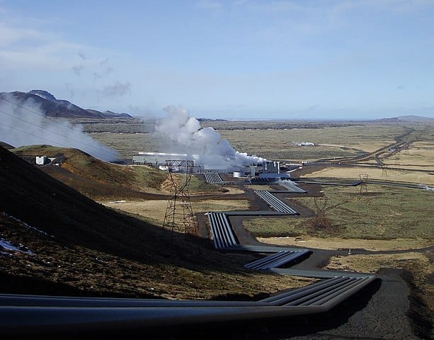
The Hellisheidi Power Station in Iceland

While geothermal energy has had many uses in Iceland throughout history, its use there for electricity generation did not come until the increase in fossil fuels related to the energy crisis in the 1970s. Iceland’s government responded to increasing oil prices by replacing oil with geothermal energy in district heating. Government policies now strongly encourage the use of renewable energy resources in power production. 

A pilot direct air capture facility is co-located at this site. The direct air capture project was partially funded by the European Union’s Horizon 2020 program, and captures up to 4,000 metric tons of carbon dioxide each year. The carbon dioxide is captured, injected into the ground, and mineralized. You can learn more about carbon storage in our course called “Put It Back”.17Hellisheidi Power Station. (2023, March 22). Wikipedia. https://en.wikipedia.org/wiki/Hellishei%C3%B0i_Power_Station

Which type of plate tectonic boundary is associated with the geothermal resources in Iceland?
Divergent or spreading zone

Correct

Convergent zone with subduction

Incorrect

Convergent zone with mountain-building

Incorrect

Image Credits

Oklahoma Academic Standards
TEKS Standards
College Board Units and Topics
Next Generation Science Standards